About Chikmagalur
- Chikkamagaluru or Chikmagalur, is a town located in the Chikkamagaluru district in the Indian state of Karnataka.
- Located in the foothills of Mullayanagiri range, Chikkamgaluru is famous for its serene environment, lush green forests and tall mountains.
- Chikkamagaluru... read more
Filter Search
New Residential Projects in Chikmagalur
Displaying 1 - 1 of 1 total results
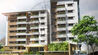
Brigade Serenity
Kadur Bypass road, Kadur, Chikmagalur
2 BHK & 3 BHK Flats
1320 Sq.ft To 2200 Sq.ft
Rs 44 Lacs Onwards
Brigade Group
Investor / Resale Options Available
+91 98205 75619
...

Read More About Chikmagalur & it's Real Estate Property Market
- Chikkamagaluru or Chikmagalur, is a town located in the Chikkamagaluru district in the Indian state of Karnataka.
- Located in the foothills of Mullayanagiri range, Chikkamgaluru is famous for its serene environment, lush green forests and tall mountains.
- Chikkamagaluru district was called Kadur district until 1947.
- It takes its name from the word - Chikkamagala Uru - which translates to - younger daughter's town - in Kannada language.
- Chikkamagaluru is also famous for coffee and is known as the 'coffee land' of Karnataka.
- It is one of the largest producers of coffee in India.
- NH -173 passes through the city.
POPULAR TOURIST ATTRACTIONS:
Amruthapura (67 km): Known for the splendid Amriteshwara temple built in 1196 AD by Amriteshwara Dandanayaka, a general of the Hoysala ruler Ballala II. This temple is an excellent specimen of the Hoysala style, with some features which are unique in design and execution. The entire temple is built using black soapstone quarried from a small hill called Annegudda, 20 km away.
Ayyanakere (18 km): About 18 kms north-east of Chikmagalur town, its located at the eastern base of the Baba-Budan range. This ancient tank is said to have been constructed by Rukmangada Raya, a chief of Sakrepatna and renovated later in 1156 AD during the Hoysala times. The tank now provides irrigation facility to about 1,500 hectares of land.
The Bababudan Range: Also known as Chandra drona parvatha, this mountain range has some of the highest peaks after the Himalayas and the Nilgiris, like Mullayanagiri (1930 meters) and Baba Budan Giri (1895 meters). The peak, Baba Budan Giri is named after the Muslim saint Baba Budan, who is said to have planted seven seeds of coffee he had bought back from his pilgrimage to Yemen, which later spread to other regions.
Sri Guru Dattatreya Bababudanswamy's Dargah: Respected by both Hindus and Muslims, this dargah is in the vicinity of famous waterfalls - Gada Theertha, Kamana Theertha and Nellikayi Theertha. A cave here is believed to have been sanctified by the residence of Shri Dattatreya Swamy and Hazarat Dada Hayath Mir Khalandar and other saints.
Ballala Rayana Durga: The ancient ruins of the Hoysala fort are located on top of a hill. One can have an amazing view of the Western Ghats from the parapet of this ancient fort.
Balehonnur (45 km): Located on the banks of river Bhadra in Narasimharajapura taluka, the famous Shrimad Jagadguru Rambhapuri Veerasimhasana Mahasamstana Peeta (matha) and the Veerabhadra Temple are the main attractions here.
Belavadi (29 km): Belavadi, also known as Ekachakranagara is a village dotted with temples and shrines. The most famous of them is the Veeranarayana temple - a fine example of Hoysala architecture. Belavadi is only 10 km north-west of the Hoysala capital of Halebid.
Bhadra Wildlife Sanctuary (38 km): Bhadra Wildlife Sanctuary is 38 km north-west of Chikmagalur town and home to a large variety of wildlife. The sanctuary is surrounded by Mullayanagiri, Hebbe Giri, Gange Giri and Baba Budan Giri hills and has the tributaries of the Bhadra River flowing through it.
DEMOGRAPHICS:
- As of the 2011 India census, Chikmagalur had a population of 1, 18, 496 people.
- Males constituted approx 51 percent of the population while females were at 49 percent.
- Chikmagalur has an average literacy rate of 72 percent which is higher than the national average of 59.5 percent.
- Male literacy here stands at approx 80 percent while about 73 percent of the female population is literate.
- About 11 percent of the population is under the age of 6 years.
- Chikkamagaluru generally has a moderate to cool climate.
- The temperature of the city varies from 11-20 °C during winter to 25-32 °C during summer.
- Chikkamagaluru is at an elevation of 1090 meters (3,400 feet) above the sea level.
- The city as such is situated in the Deccan plateau.
JOBS & EMPLOYMENT OPPORTUNITIES:
- Agriculture is the economical back bone of the Chikkamagaluru district with the mainstay being coffee cultivation.
- The Coffee Board located in Chikkamagaluru town is the government authority that oversees the production and marketing of coffee cultivated in the district.
- Coffee is cultivated in Chikkamagaluru district in an area of around 85,465 hectares with Arabica being the dominant variety grown in upper hills and Robusta being the major variety in the low level hills.
- There are around 15,000 coffee growers in this district with 96% of them being small growers with holdings of less than or equal to 4 hectares.
- The average production is 55,000 MT, which includes approx 35,000 MT of Arabica and 20,000 MT of Robusta.
- The average productivity per hectare is 810 kg for Arabica and 1110 kg of Robusta, which are higher than the national average.
- Chikkamagaluru district unfortunately has not made good progress in terms of industrial development.
- Inadequate infrastructure and poor connectivity are two of the main reasons why the district is backward in this aspect.
- There is only one medium-sized company, Vignyan Industries Ltd here at Tarikere. A subsidiary of BEML, it produces steel castings.
- There are two industrial estates in Chikkamagaluru district, one near Chikkamagaluru town and the other near Birur in Kadur taluka.
- The Chikkamagaluru Industrial Estate is spread over 13.20 acres of land where the one at Birur is spread over about 11.1 acres.
- Karnataka Industrial Area Development Board (KIADB) is also developing an Industrial Area of over 145 acres near Amble village of Chikkamagaluru taluka.
TRANSPORT & CONNECTIVITY:
- The poor state of the roads and rail network has hampered the development of this district.
- The total length of roads in this district is 764 km.
- There are only two National Highways that pass through this district.
- NH-13 (Sholapur to Mangalore) passes through the towns of Koppa and Sringeri while NH-206 (Bangalore to Honnavar) passes through the towns of Kadur, Birur and Tarikere.
- There is a proposal to upgrade the existing state highways Tarikere-Belur, Sringeri-Hassan & Kadur-Mangalore to national highway status.
- The total length of railway line passing through the district is 136 kms.
- Birur is the main junction of Chikmagalur district.
- A new railway line connecting Chikmagalur to the main Hubli-Bangalore trunk line has been opened and work on a new line connecting Chikmagalur to the Bangalore - Mangalore trunk line has commenced.
- Chikkamagaluru district has a small airport near Gowdanahalli village about 10 km from Chikkamagaluru town, which is only suitable for small, chartered aircraft.
- Passenger airlines use the airports at Mangalore, Bangalore and Hubli.
INFRASTRUCTURE OUTLOOK:
- The district suffers from the lack of a quality road and rail network that has kept investors away.
- The Karnataka Industrial Area Development Board has developed an industrial area in the district near Amble village of Chikmagalur taluka, about 7 km from Chikmagalur city.
- KIADB has acquired 145 acres of land of which 55 acres of land have been developed with infrastructure facilities like roads, drainage and water supply.
- Five bore wells have been dug and a ground level storage reservoir of 30,000 gallons has been constructed.
- KIADB has also installed 4 transformers of 250 KVA capacity each which will get power from rural feeder.
- 57 Industrial plots measuring from quarter acre to six acres have been formed and ready for allotment in the first phase.
- KPTCL has acquired land at Hiremagalur near our Amble Industrial area for setting up 11 MVA sub-station for supply of power through an express feeder.
- District industries centre in association with KIADB are planning to identify and develop industrial areas in Kadur taluka and other taluka of the district.
- The Karnataka State Small Industries Development Corporation has developed two Industrial estates in Chikmagalur district namely, Chikmagalur Industrial estate (Chikmagalur) and Birur Industrial estate (Kadur taluka).
- KSSIDC has developed the infrastructure facilities like roads, drainage, and water supply at both estates while power supply is through an urban feeder. There are 2 transformers of 250 KVA capacity each installed here.
- KPTCL plans to establish sub stations at Kalasapura, Yagati, Neralakere, Shivani, Muthinakoppa in addition to upgrading few stations, replacing transformers and circuit breakers and providing additional transformers.
REALTY MARKET OVERVIEW:
- The real estate market here is primarily driven by end users.
- The lack of adequate infrastructure facilities has served as a damper with regard to real estate development here.
- Some of the reputed developers active here include QVC Realty and the Bengaluru-based Brigade group.
- QVC Realty has announced plans to launch a second home community project here, which will be set around a nine-hole golf course amidst lush green forest and calm and serene surroundings.
- Brigade Group’s ongoing Serenity project here offers a choice between 2 and 3BHK apartments with possession slated form sometime in October 2016.
- Demand is mostly for large plots of land and vacation home projects.
- Price of residential property here is in the range of approx INR 4,000-4,500 psf.
- Nearby locations like Joythinagar and Kalyananagara are seeing an increased level of realty development activity.